THE MARSH
The drained mosses on Heversham Marsh may seem to be of recent origin but in fact they were formed in the first centuries after the retreat of the ice by the deposition of decaying vegetation which in time created peat bogs over thirty feet deep. Probably it was the easily culled wild life of the mosses that first lured early mankind to Heversham. Later the peat diggings were a valuable source of fuel and until the 1950’s Heversham parishioners possessed peat digging or ‘turbary rights’ on the marsh. Heversham Cottage and several old properties in the village and in its satellite hamlet of Leasgill still retain their peat sheds. Later still, when a sea banking was built to hold back the spring tides and dykes were cut to drain the marsh, alluvial and peaty silts provided valuable (and in this area –scarce) arable land.
WILD LIFE
Heversham Marsh was valued by earlier inhabitants for its abundant wild life. In 1694 the antiquary Thomas Machell recorded ‘here are a great store of duck, mallard, tiel and wild geese’ and the far side of the estuary is significantly called Foulshore. Machell also noted that the estuary contained ‘Sallam, morts, sprats, trouts, eels, smelts, fork tails and the like…pikes are a yard long’. The most numerous fish were flounders known here as flukes which could easily be caught by treading particularly near the appropriately named Fishcarling Head which is still within the Heversham Parish boundary. In 1774 William Hutton stated that shrimps were plentiful and in 1843 the Westmorland Gazette reported that three cwt of salmon had been collected from the upper sands, presumably from around Heversham. They would have been pooled fish left stranded in shallow water by an ebbing tide and an easy prey to the watchful bay folk.
There is also ample evidence of native wild animals. Bones excavated at Watercrook show that venison was part of the Roman soldiers diet. Excavations at the Dark Age (c.500-900 AD) site on Haverbrack – two miles across the estuary from Heversham-produced the bones of wild boar, 50 wild dogs and five wolves. The wolf remains confirm the tradition that England’s last wolf was killed on Humphrey Head at the entrance to the Bay and Ulpha Cragg nearer to Heversham derives its name from the Old English word for wolf.
Vermin. Other species are mentioned in Heversham Church records. In 1609 the Parish Clerk paid ‘ Mr Chamber’s man for a fox head 12d’ and Anthony Johnson for a fox head, 4 catts and 2 Brocks 2s 10d’. In 1805 the Church Wardens paaid 2s 6d for 14 foulmarts (pine marten). Though Heversham has not been a great hunting area foxes are relatively numerous and in 1953 Sam Birkett shot five foxes on Heversham Head during one winter’s afternoon.
BUILDINGS MATERIALS
Clay. For a brief period at the beginning of the nineteenth century the alluvial clay from Heversham Marsh was exploited for brick making. Between 1816 and 1817 a million bricks came from the brick ponds below Moss Side farm to roof Hincaster Tunnel on the Northern reaches of the Lancaster to Kendal Canal. Thirty years later Heversham bricks were used for bridges and other works on the section of the London and North Western Railway which ran along the eastern edge of the parish. Even so brick remained a rare building material in Heversham. As late as 1907 it was cheaper for the Church authorities to build a shed for the coffin bier (which also doubled as a person pulled ambulance) from stone than to use bricks.
Limestone. Throughout Heversham’s history coursed limestone rubble bound with lime mortar was used for most Parish buildings. Much was rived from the building site and in the early twentieth century ‘High Meadows’, ‘Hillside’ and ‘Infield’ on Woodhouse Lane and ‘Fairmead’ on the Princes Way were constructed from masonry derived from adjacent ‘stone holes’.
Mortar came from locally burned lime and limekilns provided farmers with a useful extra income. When demolished in c.1920 the limekiln at Parkhouse was big enough to provide the masonry for a house ‘Spring Lea’ built by Mr Barnes when he retired from the farm.
There were several masonry quarries in the Parish including one at the southern end of Princes Way which was filled in around 1980 and another near East Brow on Woodhouse Lane which produced a pink tinged stone some of which may be seen in the walls of the Parish Church.
The main Parish Quarry was on the south western corner of Heversham Head on a site marked on Ordnance Survey maps as Bottom Wood. Even in the 21st Century it is possible that parishioners may have rights to collect stone from here for their own homes, garden edgings or field walls.
Heversham’s limestone is porous and house walls were invariably rendered with a pebbly plaster which in the nineteenth century evolved into pebble dash. Farm buildings were not rendered even when as at Deepthwaite Farm and (before late twentieth century demolition) at Lower Haverflatts Farm and the Eagle and Child they were under the same continuous roofline.
Originally most roofs were thatched with reeds collected from the mosses. The steep pitched roofs of some older properties like sixteenth century Hincaster Hall indicate that they may have been thatched. In 1772 the Grammar School authorities spent £75 on replacing with slates the thatched roof of a newly acquired boarding house in the centre of the village.
To provide gravel and sand for building purposes several non-stone quarries were scattered round the Parish. A bumpy field at Milton Moor still clearly shows the craters formed by gravel digging. Another ‘quarry’ was at Leasgill which later became a site for Sissons’ joiners shop. When after over a century the Sissons relinquished the site it came as a surprise to many that the land was Parish Property and that it was called ‘Leasgill Quarry’-but such is the long arm of history.
DATE STONES
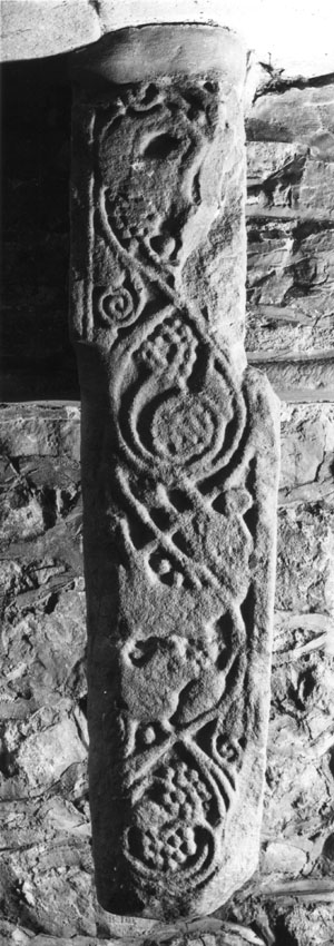 |
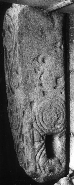
The Anglian Cross in the Church Porch showing the Christ Vine
entwining primitive beast typical of eighth century sculpture.
Please click on the images to enlarge. |
Local limestone is difficult to carve which may account for an almost total lack of ancient date stones in Heversham. The oldest date stone in the parish is 1602 in the Levens Chapel in the Parish Church.
It bears the bugle horn crest of the Bellinghams of Levens
Hall and commemorates their part in the restoration of the Church after
a fire in 1601. ‘E.W. 1613’ is carved on beam over
the entrance to the former Grammar School’s ‘Big School’ (now part
of Dallam School’s annex).
It was brought there in c.1876 from the old Grammar School
on Heversham Head and refers to Edward Wilson’s foundation of the
school.
The oldest date stone on a house is 1691 at Lower Haverflatts
though
after reconstruction in the 1990’s not much remains of
the seventeenth century building.
The opposite is the case at Lower Rowell Farm which has a stone inscribed R P 1719 but, as the house appears to be over a century older, the date probably refers to Rowland Parker who lived there in the early 18th century. Horncop House has a date stone of 1732 but this was inserted by its owner and architect J. F.Curwen when the house was built in 1899-1900. The barn of Heversham House and is inscribed W D S 1791 below the flaming crescent crest of the Wilsons of Dallam and this survived the barn’s conversion into dwellings in the 1960’s.
TIMBER
Wood for construction purposes was always plentiful around Heversham though huge trees associated with areas of timber building like Cheshire are comparatively rare. Even so there are massive oak beams of medieval origin at Heversham Hall, in the Elizabethan barn at Parkhouse and in the nave roof of the Church of 1601 - 1611.
VILLAGE CRAFTS
Coppice wood from hazels and other lower growing trees also provided materials for swill (basket) makers, cloggers and coopers. Local barrels were needed during the eighteenth and nineteenth centuries when gunpowder was manufactured two miles away at Sedgwick. Moreover, although, compared to many other places, Heversham has lacked village industries it has always been home to several jobbing builders and joiners. For nearly two hundred years members of the Sisson family have followed both crafts in the village.Nothing has survived of a Maltkiln that existed before c.1850 in the garden just north of Crow Wood but a shed used by a village cobbler still stands behind Heversham Cottage on Woodhouse Lane. From more modern times dates the former tailors shop in the garden at High Field, Leasgill. The sale room was on the ground floor while the sewing room lit by roof windows was up stairs. Until the 1930’s Heversham also had a flourishing Smithy, the forge and workshop being across the road from the house still called Smithy Cottage. A photograph of iron hoping a cart wheel in c. 1920 at Heversham Smithy has become one of the most evocative local illustrations of the lost world of village industry.
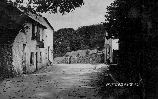
|
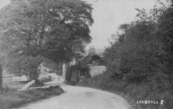
Leasgill Brow c. 1910. The road over the Brow was made in
1826. The old `low road' can be seen branching off to the left.
To the right is Leasgill Cottage once the premises of Miss Salkeld's
School. Please click on the image to enlarge |
TRADE DIRECTORIES
A random selection from Trades directories indicates something of Heversham's mixed economy. In 1829 Parson and Whites’ Directory entered for Heversham 26 farmers including 11 yeomen; Thomas Armer shoemaker, Robert Bindloss grocer, James Clarke shoemaker, Thomas Clemmey wheelwright and joiner, William Douthwaite blacksmith, Ewan Rawlinson maltster, John Redman wheelwright, John Reed Parish Clerk, auctioneer and agent for Eagle Fire Office, George Redding grocer and William Wilson blacksmith.In 1889 Bulmer’s Directory recorded 18 farmers; Thomas Bewsher retired tailor, Francis Bond station master, Abraham Douthwaite blacksmith (at Ackenthwaite), - Germaine tailor, Martin Gott pointsman, Agnes Graham dressmaker, John Perch Hibbert barrister at law, James and Thomas McNabb joiners (at Ackenthwaite), Mrs Nelson lodgings, Henry Nicholson grocer, William Varley blacksmith, Thomas Wilson shoemaker and Thomas Wilson at Lane Cottage-joiner.
In 1930 Kelly’s Directory listed 13 farmers; Frank Birkett tailor, James Duncan grocer, Mary Hoggarth dressmaker, Herbert Kilshaw joiner, Fras. Park garage, Mary Emily Sisson refreshment rooms, Thomas and James Sisson joiners, Lillian Tailor shopkeeper (at Leasgill), Frank Todd blacksmith, Frank Varley motor garage and Thomas Wilson joiner.
In 1950 The Parish Magazine advertisements included H. Kilshaw and Son Joiners & Funeral Directors, T E Sisson joiner and W. James butcher (from Viver). In addition there were the long established joiners J. Sisson and Son and three shops: The Post Office/Newsagent (Whitwell Family), the Grocers (Sissons) and ‘Polly Hoggarths’ who allegedly sold ‘ everything from paraffin, pick axes, watering cans, tools, compasses and batteries to ‘under the counter-off the ration sweets and jammy biscuits for the Grammar School Boarders’.
COMMUNICATIONS
Heversham’s contact with the wider world has greatly been affected by the surrounding landscape. Nowhere in the north of England does the Kingdom’s Pennine backbone come closer to the North Sea coast line than it does between Heversham and Milnthorpe. In modern times this has meant that main roads, the M6, aqueducts from Thirlmere and other reservoirs, pylons of the National Grid, telecommunications from telegraph poles to telecom. ‘masts’ and gas and chemical pipelines have had to cut through the bumpy coastal lands of the parish and its immediate neighbours.
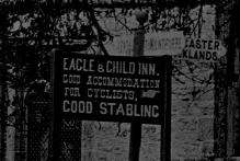
|
Heversham c.1900 showing the sign advertising `Good Stabling'
at the Eagle and Child. Please click on the image to enlarge |
|
|
Nevertheless, Heversham for most of its history was an isolated place. Mountain routes like Shap Fell to the north deterred most Scottish invaders who preferred to detour round the Cumbrian Coast and then splash across Morecambe Bay from Furness into the English heartland. This accounts for most of the medieval small defensive fortresses designed to protect the local inhabitants from the Scots or other bad neighbours being close to the coast. These fortlets are called Pele Towers one of which may have been at Heversham Hall; other examples within four miles of Heversham are Dallam Tower, Hazelslack Tower, Arnside Tower, Nether Levens (Lower Levens Farm), Levens Hall and Sizergh Castle.
Post Ice Age marshland affected Heversham’s communications. Hale Moss four miles to the south was not crossed until the 1800’s when John Macadam built what became the A6 road. Until then the main north-south route between Kendal and Lancaster was not through Heversham but via the higher and drier land through Crooklands and Burton-in-Kendal, to the east. Thus, although the Churchwardens accounts record ‘1s spent when the Church Plate was hid’ at the time of the 1745 Jacobite Rebellion. Bonnie Prince Charlie took the ‘high road’ rather than the ‘low –and boggy- road’ road through Heversham and Beetham.
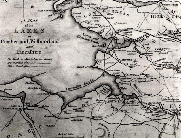
|
West's Map 1780 showing Heversham and `Millthrop's' historically important
proximity to the Irish Sea. The old main road from Kendal to Lancaster is clearly shown going through Burton, The north-south route through Heversham is a mere track. Please click on the map to enlarge |
In 1759 The Kendal to Dixies Turnpike Act provided for the improvement of the road between Kendal and the port of Milnthorpe at Sandside. This road ran through Heversham. The Toll House was at the Ninesergh Lane end where the Prince’s Way by-pass rejoins the old main road.
Between 1819 and 1822 the newer Turnpike was built. This provided the route now taken by the A6 and the village street. Prior to 1822 the road from Milnthorpe ran along Park House farm road then over Dugg Hill before turning sharply across the site of Dallam School to reach the village. The barn on the corner of Church Farm and the line of the ‘Post Office’ cottages still shows this alignment. At the same time a road over Leasgill Brow going east of the Athenaeum was built. Between 1815 and 1819 the final reaches of the Lancaster – Kendal Canal was built through the eastern swathe of the Parish and the Hincaster Tunnel was completed by Christmas Day 1817. The canal was opened in June 1819. It had taken 27 years to build but only had 27 years of maximum economic life before it was superseded by the railway.
The London and North Western Railway Line touched the Parish at Rowell and Woodhouse but the nearest station was east of Ackenthwaite. Though called Milnthorpe Station it was a mile from that village and two from Heversham.

|
Heversham Station about 1900.
A hundred years later the newly planted bushes on the right are all that is left of the station. Please click on the image to enlarge |
The Furness Railway’s Sandside to Hincaster branch line linking the Furness Railway at Arnside with the main LNWR line was opened in 1876. Heversham Station south of the village was opened in 1890 and closed for passenger traffic in 1941. It was demolished when the line was taken up in 1966. Curiously the station from start to last only had one Station Master Thomas Walker. Heversham Parishioner John Handley, who could remember the line being laid down, lived to see it close 90 years later!
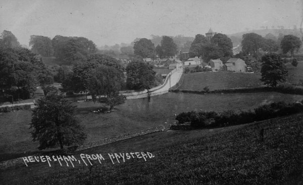
|
Heversham from Haysteads photographed before The Princes Way was built in
1927. This photograph shows how well parkland trees grow around the village. Please click on the image to enlarge |
The motor age transformed the village’s position. Because cars and char-a-bancs found the Church corner difficult to negotiate Heversham in 1927 achieved one of the country’s first by-passes in the Princes Way. Nevertheless the A6 signs (though obscured by black paint) are still fastened to the old signpost in the centre of the village. More curiously, the village can claim to be about half way along the diagonal route across Great Britain: Land’s End and John O’Groats are both 418 miles from Heversham!
INNS
Though travellers were scarce Heversham possessed three inns during the eighteenth century. Opposite the church on a site now occupied by Chestnut House was the Ship Inn. In 1772 the house was purchased by the Grammar School for a boarding house and was rebuilt. The Inn then seems to have moved next door to the house now called Sunny Vale but there are no references to it in the nineteenth century. Across the road and just up Woodhouse Lane was the Eagle and Child. This was a larger establishment providing overnight accommodation. It was closed in 1906 when it became a temperance hotel and the village Social Club. This closed in c.1970 and after many years standing as an eyesore it was converted in 1993 into separate houses.
|
The Blue Bell on the left in c.1900. On the right is Smithy Cottage. Please click on the image to enlarge |
Heversham’s main Inn was the Blue Bell which stood on the west side of the road just north of the Church. Its facilities included a large assembly room which became the centre for all sorts of social activities. Though the Inn closed in 1952 its pre 1914 advertising board remains on the north wall of the building and some of the wording like ‘good stabling’ can still be discerned.
The ‘old’ Blue Bell’s liquor license was transferred to the Heversham Hotel which occupied a partly 16th century house called Elm Lawn that until 1842 had been the Vicarage. It had become an Hotel after the Princes Way was constructed across its lawns but for its first years only had a table license. In 1966 the Hotel was renamed ‘The Blue Bell at Heversham’.
THE CHURCH
Heversham’s historic isolation had a direct bearing on its two most important institutions the Church and the Grammar School.
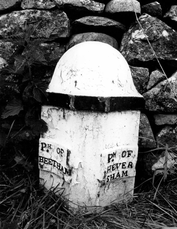
|
Heversham Parish Boundary post Paradise Lane, Ackenthwaite,
which is now part of Milnthorpe Parish. Please click on the image to enlarge |
Along with other places on the rocky and isolated coast of Britain Heversham can claim to have been continuously Christian ever since the days of the Romans. Indeed the first missionary may have been Roman Christian soldier tramping along the road connecting Watercrook via Hincaster with the Roman high road in Lunesdale. Unlike the east and south of England, Heversham was not penetrated by the pagan Angles and Saxons until long after their leaders had been converted to Christianity following the mission of Augustine in 597 AD. Even so it seems that Heversham may have received a transfusion of the faith by missionaries from the Celtic Church of Ireland who also possibly founded St. Patrick’s Church at Heysham fifteen miles down the Bay. The name of Ninesergh Farm on the banks of the river Kent is sometimes considered to be a reference to Ninian one of Patrick’s saintly band. More certainly a monastery existed at Heversham from the sixth century until it was probably destroyed during the raids of the Norse Vikings 300 hundred years later. It is a reference of c.911 AD in the archives of Lindisfarne Monastery to Tildred Abbot of ‘Hefresham’ seeking refuge from the fury of the Norsemen that provides Heversham Church with its earliest record.
Celtic monasteries contained members of both sexes and their way of life was more like that of a twentieth century religious commune than the highly disciplined and celibate Abbeys and Convents of the Middle Ages. Possibly a group of huts close to a well and grouped round a stone cross formed the nucleus of the community on the site of the present Church. Happily one ‘most precious monument’ of the Celtic monastery survives in a large fragment of an eighth century Cross Shaft which has stood for 150 years in the Church porch. Composed of Lancaster sandstone and carved with Christ Vine motive typical of other North Lancashire it may have been rafted round the coast and borne over the marsh on a spring tide to land close to its current position. Similarly the sandstone for the pillars of the c1180 south arcade of the nave and the masonry and window tracery of the fifteenth century Chancel could have been brought to Heversham by sea.
THE ANCIENT PARISH OF HEVERSHAM
A small and sparse population meant that the one church at Heversham served a wide area. Until the nineteenth century Heversham Parish included the later independent Parishes of Crosthwaite and Lyth, Crosscrake (Stainton, Barrows Green and Halfpenny), Levens (formerly called Beethwaite Green), Preston Richard (Endmoor and Milton) and Milnthorpe (with Ackenthwaite). Milnthorpe’s ecclesiastical connection with Heversham is illustrated by the name of Church Street which to the confusion of all strangers leads not to Milnthorpe Church built in the centre of the village in 1837 but to the old Church at Heversham. Moreover, the Cross Key’s Inn at the Milnthorpe end of Church Street refers to the badge of St Peter the patron saint of Heversham Church.Because Milnthorpe was carved out of Heversham its parish covers a comparatively small area. Part of Milnthorpe’s Civil Parish is within the Ecclesiastical Parish of Heversham including much of Ackenthwaite and also the west side of Church Street as far south as Grisleymires Lane which takes in Kirkgate Field and Dallam Chase.
PARISH CHARITIES
Some of the Charities arising out of bequests extended over the whole Parish on ‘both sides of the mosses’ - meaning Crosthwaite and Lyth - as well as Heversham with Milnthorpe, Preston Richard, Preston Patrick and Stainton. Those charities appertaining to Heversham are invariably linked with Milnthorpe. When Milnthorpe became a separate Parish in 1896 it was arranged that, generally, the greater share of the charity’s income should go to Milnthorpe because it had most inhabitants. The Milnthorpe Consolidated Charities still uses the income from these charities and at Christmas in 2000 some 40 elderly residents were given £5 each by the Parish Council which administers the Charity. It is not known whether a similar arrangement exists in Heversham.The Ancient Charities of Heversham with Milnthorpe include The Woodhouse Charity incorporating Martingdale’s Charity. This derived its income from a bequest made by Agnes Martindale in 1761 and renewed in 1769. She left a sum which was worth £84 in 1793 to provide income to be distributed to ‘the six poor widows of Milnthorpe town’ and for other ‘poor householders’.
In 1793 the residue of this charity and accumulated ‘poor funds’ from other sources were used to buy a small farm at Woodhouse along with some outlying holdings on Heversham Head and on the Mosses. This produced an annual rental of £40 which went to the Poor and also to the Apprenticeship Fund used for ‘putting out boy apprentices’. The Woodhouse Charity Estate was sold in 1927 and the proceeds invested for the charity fund.
As late as the 1960’s Apprentice Money was still paid in Milnthorpe.
Bread Money
This derived from invested collections taken at Holy Communion
which was only held 10 times a year. In 1820 the fund stood
at £80 but was subsequently augmented.
Loafs were given out after Morning Service-until c.1950.
The bread shelves inscribed ‘Man does not live by Bread
Alone’ are on the Church wall behind the font.
Atkinson’s Charity.
In 1811 Thomas Atkinson left £21 to produce £1 1s pa to be divided amongst the poor people of Heversham and Levens.
Gibson’s Charity.
In 1701 Robert Gibson left his ‘share in the tythe barn remaining within Stainton’ (near Ulverston) and other property to produce 40 shillings pa for poor children born within the townships of Milnthorpe, Heversham, Ackenthwaite, Rowell and Woodhouse.
Johnson’s Gift.
In 1802 Robert Johnson of London left £200 which produced an income of about £11 which was used to provide poor persons with bread or clothes.
The Tattersall Almshouses.
In 1884 William Tattersall from St Anthony’s House built and endowed six Almshouses situated on Milnthorpe Hill. They were for ‘those who have once occupied better positions in life but such who have been reduced through circumstances over which they had no control’. These Almshouses traditionally have the Vicar of Heversham – or his nominee - as a trustee. Because of this when the ecclesiastical parish of Heversham and Milnthorpe was divided in 1924 the Almshouses and all the land on the west side of Church Street as far south as Grisley Mires Lane were retained in Heversham’s Ecclesiastical Parish although this area is within the Civil Parish of Milnthorpe.
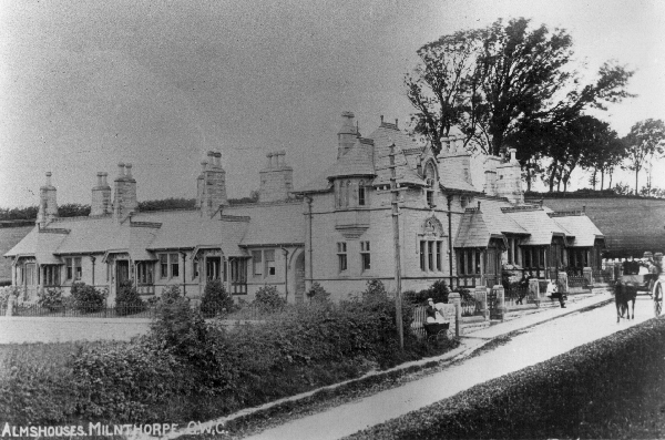
|
The Tattersall Almshouses on Milnthorpe Hill shortly after
they were built in 1884. This area is part of Heversham ecclesiastical parish and the fields behind and in front of the almshouses are now occupied by Kirkgate Field and Dallam Chase developments. Please click on the image to enlarge |
The Rhoda Thompson Trust – also known as ‘The Vicar and Church Wardens Trust’.
Little is known of this newest Parish Charity other than
what was stated by the Rev Cleghorn when Rhoda Thompson’s
bequest was explained to the PCC on the 29th July 1947. Mr Cleghorn said that Mrs Thompson had ‘bequeathed her
residence, The Knoll, for use as a vicarage, the residue of her
estate which would be worth at least £4,000 and a reversionary
interest after two lives on £10,000. First among the objects
for which she wished her money to be used was the maintenance of the fabric
of the church’. Allegedly, some of its funds were used in
the 1950’s to finance Heversham Grammar School’s library and in
the 1960’s to modernise the Vicarage.
In the 1950’s The Trust bought
a building site on Woodhouse Lane and the premises of the former Eagle
and Child with an adjoining paddock. When the building site and
the Eagle and Child buildings were sold the proceeds went towards the
cost of building an assembly hall at Heversham Church
of England School. It is not known what residual funds exist
or to what purposes they are devoted. The Vicar and Church Wardens
are the trustees of this charity; hence its apparent change in
name.